|
|


|
The desert southwest is truly an amazing place, with vast nothingness that extends as far as the eye can see--or does it? We recently spent five days exploring Southern Utah and Colorado, crawling through ancient Pueblo Indian ruins, traversing deep canyons and touring grand Arches. The focal point (pun intended) of the trip was Arches and Canyonlands National Parks, however, given how large the area is, we did extensive driving to some very remote locations. We also hiked many a mile through dried up river beds and deep canyons to reach locations that were usually not even on the map. In such off-road areas, we found our way via technology, i.e., my trusted iPhone GPS feature.
We arrived in Grand Junction, Colorado, and quickly made our way down Hwy 70 for the 2-hour drive to Moab Utah, and, since there was enough time to get there before sunset, we headed for our first stop, Delicate Arch, located in the heart of Arches National Park. The hike to Delicate Arch is not long, only about 1.5 miles, but the elevation gain is 500 feet and in many places it's very steep--not a recommended hike for anyone who's not sure-footed or fairly physically fit. The trail is well marked, just follow the cairns straight up the solid rock hillside to an amazing vista. You really get a sense of the power of nature and how, when given enough time, wind and water wins out over solid rock!
The next morning, we started our day at 5am, driving into the heart of Canyonlands National Park on our way to greet the sun at Mesa Arch. I was the first photographer to arrive, and yes, my wife thought I was crazy for getting to the location at 6am when the sun wasn't scheduled to rise until 7:36am. But I told her, "by the time the sun rises there will easily be five to ten photographers all lined up and I want pole position...I didn't come this far to settle for second best." She rolled her eyes...and she's right, I am crazy. It was freezing cold, pitch dark and it was so silent, you could hear your own heart beat. So, we hiked out in the chilling, black desert. We did a quick scout of the area by flashlight, straining with the minimal light, to get our bearings of where to walk, and where to NOT walk...given there was a giant cliff only a few feet from where I was setting up. By early twilight there was just enough light to see without a flashlight, and there were also five other photographers setting up. By the time the sun began to light up the belly of the arch, as it is famous for, there were over 20 photographers lined up! It was suddenly crazy and I was pinched in the middle of the photo-manic throng with zero opportunity to move around and get a variety of compositions. I was stuck, to say the least, so I had to get creative.... Once the sun and arch started doing their thing, I was desperate to get a better composition, but since moving was not an option, I took down my Canon 1Ds Mark III and exchanged it for my Canon 1D Mark III, which has a 1.3x crop factor. I put on my fisheye and voila, a wider scene without the full fisheye effect (due to the sensor crop factor). I know, I'm brilliant, what can I say? Kidding aside, what a place...a giant rock arch spanning a shear cliff drop, hundreds of feet to the valley floor. I know many of you have been there and know what I mean, but for those who haven't seen it in person, put this near the top of your to-do list...it's amazing.
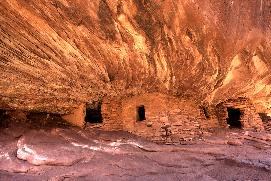
Next on the list for the morning was a 2-mile hike to the top of a small hill known as Aztec Butte. This mountain top contains the remnants of Pueblo Indian granaries, stone food storage areas built into the side of the sandstone. They would stack up rocks and then pack them tight with mud mortar, keeping their food cool, dry and safe from animals. These people were really quite resourceful. We spent the rest of the day driving around, seeing all the grand vistas and making mental notes of other possible photographic locations in better lighting conditions. That afternoon, by direction of GPS only, we started a hike that I'd been planning and looking forward to for many months--to find the mysterious False Kiva, a Pueblo Indian ruin. (This well-known ruin is often referred to as Anasazi, however, my understanding is that Anasazi is incorrect and an insult to the Pueblo Indian ancestry).
False Kiva is not easy to find, or to get to, and in the tradition of those before me, I'll share information about it if you contact me, but I won't publicly post any details other than GPS coordinates* (see below). This is a very special place that is not on any map, not even the park maps. It's that way for a reason...the National Park Service does not want a ton of people to visit it and destroy the site, and I can see why. The hike, as I mentioned, is not easy. The cairns (piles of rocks used as a landmark or memorial marker) lead the way pretty well, but the terrain is unforgiving, steep and treacherous at times...but worth every step. Once we arrived at this giant alcove, I was overwhelmed by the spiritual feeling and the incredible vista in this secluded place.
* These are the GPS coordinates I took as I stood dead center in the Kiva circle. (N 38 25.0900 W 109 54.883) If you find it, please, take only photos and leave only footprints. Since we had found the location faster than expected, we sat and waited for sunset. I shot for about 15-20 minutes when the light was at its peak, and then we started the steep climb back out, just as the sun was setting. What an amazing experience!
A great deal of the next day was spent on the road driving hundreds of miles to several different locations. We eventually hiked into Mule Canyon to photograph Indian dwellings built into the side of rocky alcoves, and to Mesa Verde National Park, to tour and photograph some of the largest, and most well preserved Pueblo dwellings. The attention to detail and intelligence they displayed in how they built these large complexes was amazing to me.
I climbed down into one of the kivas, camera equipped with my fisheye lens. I plastered myself as flat against the wall as humanly possible and fired off a few exposures. This is a small space, about 12 feet wide, perfectly round and entirely lit only by the hole in the ceiling. I could barely stand up inside (I'm 6' 1" tall). A kiva, for those of you that don't know, was a place for ceremony and worship used by ancient Pueblo Indians--males only, no women allowed, or so the story was told. Designed with a fire pit in the middle, the shaft to the right is an air vent. The escaping heat from the fire created a vacuum, drawing in fresh air through the vent. The short rock wall was a barrier to divert the fresh air, otherwise a comfortable and safe kiva would quickly become an uncomfortable, unsafe kiva because, well, it would be totally ON FIRE!
We returned to Moab after a long, long day on the road and after hiking many miles, to rest up for the next three days. However, we didn't rest much; we spent our time exploring more ruins, petroglyphs and witnessing some of the most beautiful sunrises and sunsets you've ever seen. I know I always say this but, this is one of those places I could easily visit and photograph again. I'm already thinking about how the landscape would present itself with a light dusting of snow and how spectacular the scene would look contrasted by the vibrant colors of the desert southwest.
|